
How the Book was Done!
Michael Barry recalls a few vignettes from the writing and preparation of ‘Homage to al-Andalus’ in the period 2003-8.
The Genesis of the Book
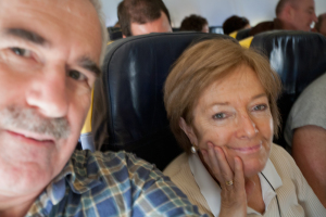
On the Ryanair express to Spain.
Veronica and I were walking in the hills near Estepona (in Malaga Province, Andalucía) . Through the red dust of a mule track over a ridge leading to the Sierra Bermeja, overlooking the Mediterranean. I came upon a small hill which dominated the ridge and the valleys around. There were the remains of buildings, little more than rubble, in stone and pieces of red brick. A scrappy local map indicated that these were “Moorish ruins”. This sparked my interest. ‘Who were these people? What were they doing here? How did they live? I went to look in bookshops and searched on Amazon. I couldn’t find any book which gave a simple answer. There were lots of books of an academic bent, which characteristically got diverted up obscure cul-de-sacs. I could not find a book that told me plainly and simply in a linear fashion the story of these people and their era. (Later I discovered that the name ‘Moors’ is a misnomer, as most never came from Morocco. Generally they were of local Iberian origin, converted to Islam over the centuries of al-Andalus).
Having written books previously, I resolved to write an accessible book on the era of al-Andalus. (Al-Andalus: Islamic Spain and Portugal. Originally it extended over most of the Iberian Peninsula, but progressively was reduced so that by the middle of the thirteenth century it was confined to the Kingdom of Granada, more or less the territory of present-day Andalucía.) Over the years, I went on the road around the Iberian Peninsula, seeking out vestiges of al-Andalus. Several of my adventures, where I discovered more than al-Andalus:
A stumble in Ronda
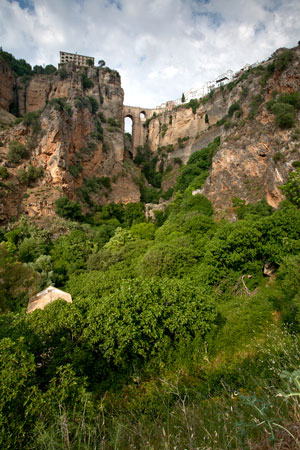
Looking up at the Puente Nuevo, which spans the Tajo de Ronda, through which runs the Guadalevin river. I lost my footing here, trying to recapture the scene from a photograph from 1918.
Ronda, an exquisite white town in Andalucía, was an important Taifa (or statelet) in the eleventh century. It has extensive buildings and city walls and defences dating from that era. My big project in Ronda: to take a photo of the famous bridge over the deep gorge, the Tajo de Ronda. Armed with my camera and tripod, I walked down into the deep gorge, generally on rough paths. I passed the remains of old defensive walls from the taifa era, made of rammed earth, on the way. Along the edge of the abyss I saw the remains of a small abandoned power station, early twentieth century. I traversed along a narrow track and had a look inside. The roof was gone, it was muddy and overgrown. I gingerly retraced my steps and continued. About a year previously I had bought a poster of the bridge from the tourist office in Ronda, which showed the bridge in a photograph of 1918. The photograph was utterly dramatic and I wanted to reproduce the same shot. I progressed to my goal. The path ended. I navigated my way around a field of fennel and set up the tripod and took photos. It was an evening sun, but not too strong. I noted, in comparison to the old photo, buildings in the foreground had mostly disappeared. I was not in the right spot.
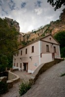
An old building by the Guadalevin River near the base of the Tajo de Ronda
I went down to the bottom as low as one could get. There was now a narrow road on the valley floor, going in the direction of the bridge. I spotted at least one of the original mill buildings. However, I was still figuring out how to line it up with the original foreground. I saw a low ridge above. I guessed that the original photo had been taken at its crest.. I climbed up the side of this ridge. It was all rough ground, with high grass. However, coming towards the end, it was impenetrable thorny brambles and I couldn’t get through. Disappointed I turned back, with the tripod slung over my shoulder. A few steps later I slipped on the sloping rocky ground. I fell heavily on my side, striking a prominent sharp rock. Wow. My side hurt like hell. I had to wait a while as I gathered my breath. Shaken, I made my way back up towards the town. It looked like a long way up and I didn’t feel too well. Slowly, I took the road back. I came to a point where a steep climb up the embankment would bring me to a higher path that led into the centre of town. I took it and got back to the hotel. Sleeping that night was sore, so onto the paracetemol. I discovered the excellence of the Spanish health system the next day when I visited the Urgencias (A&E) in Antequera.
Cordoba
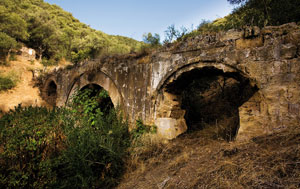
The Valdepuentes Aqueducto, about a kilometre from the ruins of Madinat al-Zahra. The Romans originally constructed a water network from the Sierra de Cordoba to supply the city. This system was diverted to serve the new caliphal city of Madinat al-Zahra.
Michael Forde (a friend of mine) and I headed off to Madinat al-Zahra (palace city of Abd al-Rahman III) to meet Senor Barasona (manager of the estate on which the aqueduct de Valdepuentes was located, which had supplied Madinat al- Zahra with fresh water), as arranged. He drove us in his 4×4 up to a gate, about 200m away. We went through the gate and walked through dry grass, past wild olive trees, with undulating rising ground. He told us that the estate was 250 hectares and this wild area was being maintained as it was. The fire breaks: he said these had to be done every year, took 10 days with machine. If it wasn’t done one would be liable for the costs of the planes that dump water to put out fires. After about 600 m we came to the ruins of a small aqueduct.

Senor Barasono and Dr Michael Forde near the Valdepuentes Aqueducto.
Then another 400m along we came to the main one, spanning a little valley. It was probably 20 m across, around four to five metres high in the middle. It was mainly open at the top now, but originally was covered over to keep dirt and leaves out. He told us that the water supply was from a limestone area, and it clogged up the inside, so that had to be cleaned on occasion. Originally the aqueduct had served Cordoba but later was diverted to the Madinat (around AD 850), while other aqueducts were brought into play to serve Cordoba. The aqueduct led into the hill, where the channel was tunnelled. He showed us the detail: the original level of the masonry was Roman, with a particular type of mortar. Later a higher level was added, so it could proceed to Madinat al- Zahra, with a different mortar.
On the way back Senor Barasona told us of at least 4 types of snakes in the vicinity, some venomous. There were also scorpions, if one lifted rocks. Towards the end he asked were we interested in seeing a monastery, part of the estate. He said ‘I know you are an Arabist’, but for himself he would find the monastery more interesting. We agreed to go with alacrity, so back to his jeep. We drove up about 800m up the track. He opened a gate and we entered into the grounds of the Monasterio de San Jeronimo de Valparaiso, now private and not open to the public.
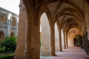
The cloisters of the15th-century Monastario de San Jeronimo de Valparaiso.
He explained it was old, that it had used stones from the ruins of Madinat al-Zahra for its construction. (Later I found out it was initially built in the middle part of the 15th century) He said that Ferdinand (of los Reyes Catolicos fame) had stayed there while he was planning the taking of Granada, as did Felipe II. He said the monks were expelled from here when the Spanish Government decided to take over the monasteries (they needed the money) in 1836. They took all gold and silver and anything valuable. The monastery, in ruins, was bought by a private individual and was bought by the owners in 1910. Without any state aid they have been doing extensive restoration over the years. It all looked well maintained. The chapel had no roof. Senor Barasona said it would be difficult to restore as there were a mix of styles, gothic, baroque and modern.
Thanks to this courteous man, we were lucky to have the opportunity to see some of the hidden architectural heritage of Spain.
In the Misty North
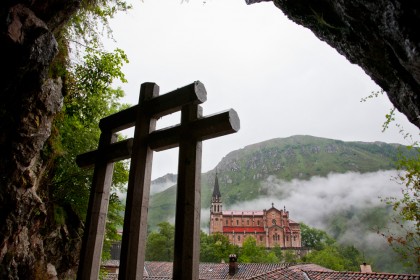
The cross is silhouetted at Covadonga (near Oviedo), a place where the Spanish celebrate the ‘Reconquista’. A Visigothic nobleman, Pelayo is reputed to have repulsed Muslim forces here in an encounter around AD 718.
The Arab invaders had no wish to occupy the misty, cold and rainy mountains in the north of the Iberian Peninsula. In 718, they had a skirmish at Covadonga with a local Visigothic nobleman called Pelayo, who defeated them. I flew into Bilbao from Dublin and hired a car. I set off through torrential rain, heading for Covadonga (near Oviedo) in the western foothills of the Picos de Europa.
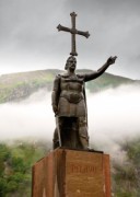
Pelayo: the Visigothic nobleman, among the misty mountains, at Covadonga.
I duly took my photograph of the statue of Pelayo, suitably framed against a misty backdrop. Time to explore the other aspects of the site: it is an extraordinary place. It has developed into a Catholic place of pilgrimage. There is a church and several shrines. Many busloads of Spanish people congregate there every day. It is considered as the start of what some call the ‘Reconquista’. The name ‘Covadonga’ was suitably inspirational to the Spanish Falangists to be used as a code word during the run up to the rebellion against the Republic in 1936.
Pelayo is important, as the traditions of the Visigoths were transmitted via his descendants to the Christian kingdoms that emerged in the north of Spain. These later became imbued with a crusading spirit of Christianity, so that, more than three centuries after the battle of Covadonga, the conquest of territory began in earnest.
Jaen
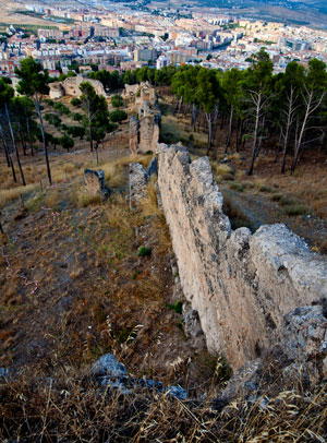
View of the 12th century Almohad defensive walls snaking down towards the city of Jaen, from the heights of Santa Catalina.
The Castle of Santa Catalina in Jaen, as is common with castles in Spain, had Muslim origins, with later Christian additions. It is in an excellent strategic situation: high and long, it dominates the city, plain and mountains all around.
I found a rough track and I set off to investigate the ruined curtain fortress walls, of Almohad origin, which snaked down to the city.
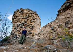
An exhausted author takes a break by the ruined Almohad walls of Jaen.
I went through a rough field with vestiges of a track. As usual I took many photographs of what was in many cases vertical honey-coloured rubble. After beating my way through bushes and obstacles, eventually I reached the laneways of the highest barrio of Jaen, as the sun was beginning to set.
Atzuvieta
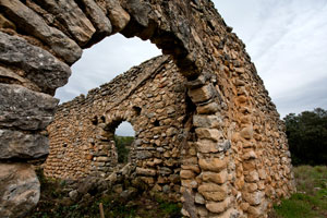
The ruins of Atzuvieta, a Morisco village in the Marina Alta (near Valencia). The inhabitants were expelled from here in early seventeenth century.
This place is part of the sad last chapter of the story of al-Andalus. Adzuvieta is in the mountainous Marina Alta of the Communidad de Valencia. During the 17th century Valencia was heavily populated with Moriscos (Iberian Muslims who were forced to become baptised Christians, living under Christian rule). Distrusted by King Felipe III, conscious of the rising threat of the Ottomans in the Mediterranean, he decided to expel them from Spain. Valencia’s turn was first. A decree of expulsion was published by the Viceroy in Valencia in September 1609. The Moriscos in each locality were given three days to arrive at specific gathering points whence they would travel to the disembarkation ports. Ships would then transport them to North Africa. By the middle of 1610, all the Moriscos of Valencia had been rounded up and expelled from the kingdom, an estimated number of around 120,000. The process was repeated in the rest of Spain.
So, it was with a sense of poignancy and sadness that Veronica and I walked amongst the ruins of Atzuvieta, where the inhabitants had been forced to leave around 1610. The village, one of several similar in the regions, had never been re-populated.
Veronica in a pensive mood at Atzuvieta.
The concept of expulsions of peoples; the theme of abandoned villages, and the similarity with the abandoned famine villages (from the time of the devastating Great Famine in Ireland in 1845-49) was picked up by Robert Fisk in his article in the London ‘Independent’ 0f 4 May 2014 when he wrote:
‘Lost lands are littered with the homes of those who lived there. Armenian houses in south-eastern Turkey. Abandoned Palestinian homes in Israel. German property in what was the Sudetenland and Prussia. There are Greek homes around Smyrna – now Izmir – and down the west coast of Ireland lie the roofless cottages of those who died or emigrated in the Great Famine. Michael Barry, an Irish engineer and railwayman, has recorded the broken homes of the Moriscos – “little Moors” – of Spain, the very last Muslims to be driven out of Andalusia in 1613. His photographs of arched stone walls, roofless cabins and broken timbers in Atzuvieta in Valencia look eerily similar to the wreckage of the 19th-century peasant houses of his own country.’